What’s in this article
The Tre Cime di Lavaredo (Three Peaks of Lavaredo) are the Italian Dolomites’ symbol. They are among the most easily recognized and photographed mountains in the world. They are part of the Sesto Dolomites and are located right on the border between Trentino Alto Adige and Veneto.
Because of the views they provide and their unique structure, they have always been a popular tourist destination for nature lovers. They have also attracted many climbers, and in recent years, free climbing lovers. But seeing them up close is doable even if you are not an experienced trekker.
They’re also known as “Drei Zinnen,” which is Tre Cime in German, because in this part of Italy, so close to the Austrian border, people commonly speak two languages, Italian and German.
In this post you’ll often find the word “rifugio,” which is the Italian term for a mountain hut. You’ll find some in scenic locations on the Tre Cime loop where you can enjoy a well-deserved beer, Italian/Austrian food, and breathe in the fresh Alps air.
And now it’s time to dive into the best way to hike the Tre Cime di Lavaredo loop. This is a relatively easy hike and is great for kids too, so if you’re planning a family vacation in the Dolomites and want to include a hike, this is a great option to consider.
SUMMARY OF THE TRE CIME DI LAVAREDO HIKE
SUMMARY – A circular hike in the Italian Dolomites that takes you around the three iconic peaks.
DISTANCE – 9.5 km round-trip
TIME: 3 hours and 40 minutes
ELEVATION – 405 m ascent, 410 m descent
DIFFICULTY LEVEL – Easy to moderate
BEST TIMES – Late May to the end of June, or early September to the middle of October.
General information about Tre Cime Park
The Tre Cime di Lavaredo are part of the Tre Cime Natural Park, which was established in 1981 to protect the area’s environmental heritage. The park was designated a UNESCO World Heritage Site in 2009. The park’s visitor center is housed within the Grand Hotel of Dobbiaco. It’s worth a visit because the center also has an interesting multimedia museum where you can see fantastic aerial shots of the peaks, and learn about the formation of the rocks and the variety of flora and fauna. The Tre Cime Park Museum is free to enter.


What to see and do on Tre Cime di Lavaredo hike
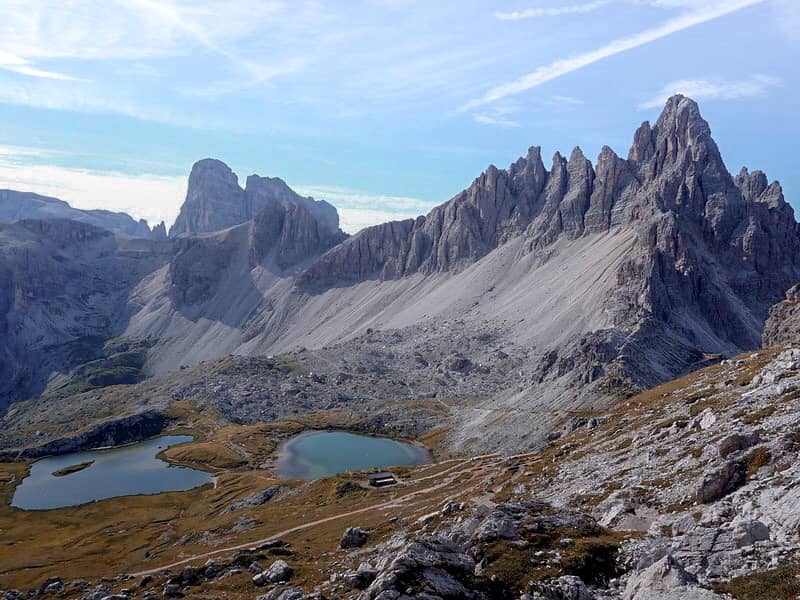
The Cima Grande, Cima Ovest, and Cima Piccola are the three mountains known as “Tre Cime di Lavaredo.” Cima Grande is in the middle and the highest, at about 3000 meters. The Cima Ovest, at 2973 meters, is the second highest, followed by the Piccola, at 2857 meters.
The best way to experience them is to hike the Tre Cime Di Lavaredo loop, a route that runs at the foot of the three famous mountains, passing through meadows and scree with no difficult slopes.
The arrival point is Rifugio Locatelli, which has the best view of the Tre Cime. The Rifugio Lavaredo, Forcella Lavaredo, and the Rifugio Langalm can all be found along the way.

Once at Rifugio Locatelli, more experienced climbers may wish to continue on the De Luca-Innerkofler ferrata, which is located on Monte Paterno and is one of the most suggestive and scenically equipped routes in the entire Dolomiti di Sesto group.
The route begins at Rifugio Locatelli and continues along the entire Monte Paterno through the scenic Sentiero Attrezzato delle Forcelle to Rifugio Pian di Cengia.
The alternation of truly unique and exciting landscapes is a highly recommended experience.
Best Time To Hike Tre Cime di Lavaredo loop
I strongly recommend you to avoid the summer months. Although the summer months have the best weather, they are also the busiest, and this is a popular walk.
The tour of the Tre Cime is just as beautiful, if not more so, at the end of spring (last days of May and the entire month of June) and between September and October, when there are fewer people. If, on the other hand, you simply must visit them during the summer, please get up early in the morning, it will help you avoid the crowds.
How long is the Tre Cime di Lavaredo loop?
The Tre Cime di Lavaredo loop is approximately 10 kilometers (about 6 miles) long and is divided into the following sections:
The distance from Rifugio Auronzo to the Rifugio Lavaredo is about 1.7 km, about 35 minutes’ walking time;
The distance from Rifugio Lavaredo to Forcella Lavaredo is about 1 km, almost 25 minutes’ walk;
From Forcella Lavaredo to the Rifugio Locatelli, 1,9 km, 45 minutes’ walk;
From Rifugio Locatelli to Malga Langalm (also called Malga dei Pastori), 2,8 km, 1 hour and 15 minutes’ walk;
2,1 km, 40 minute walk from Malga Langalm to Rifugio Auronzo.
These are estimated times, the actual time will depend on your pace and the number of stops you make.
Where does the Tre Cime di Lavaredo hike start?
The Trail of the Tre Cime di Lavaredo is a ring excursion that begins and ends at Rifugio Auronzo. It allows you to complete a full tour of the Tre Cime. It can be completed in either direction, clockwise or anti-clockwise.
I recommend walking anti-clockwise from Rifugio Auronzo; the views are better. For the most part, the paths to follow are 101 and 105.


The first section of the trail is easy to follow as it follows a well-maintained trail. You skirt the Tre Cime by walking beneath their south-facing walls, if you look behind you at this point, you will notice some peaked mountains. They’re known as the Cadini di Misurina.

There is a small church not far from the Rifugio Auronzo. It’s called Cappella degli Alpini.
Continuing along path 101, you will reach Rifugio Lavaredo. From here, you’ll have two options to get to Forcella Lavaredo:
The easiest way is to continue along the dirt road from which you arrived (a longer but less demanding route, recommended for less trained people).
The other alternative is to take the path to the left of the rifugio, which cuts through the scree slope at the foot of Cima Piccola. This is shorter but a bit more challenging.

The view from Forcella Lavaredo is breathtaking: the Three Peaks, which are so close, are truly majestic.

But, to see them from a traditional viewpoint, you’ll want to head to Rifugio Locatelli by following the signs of path 101, which runs along the foot of Mount Paterno.
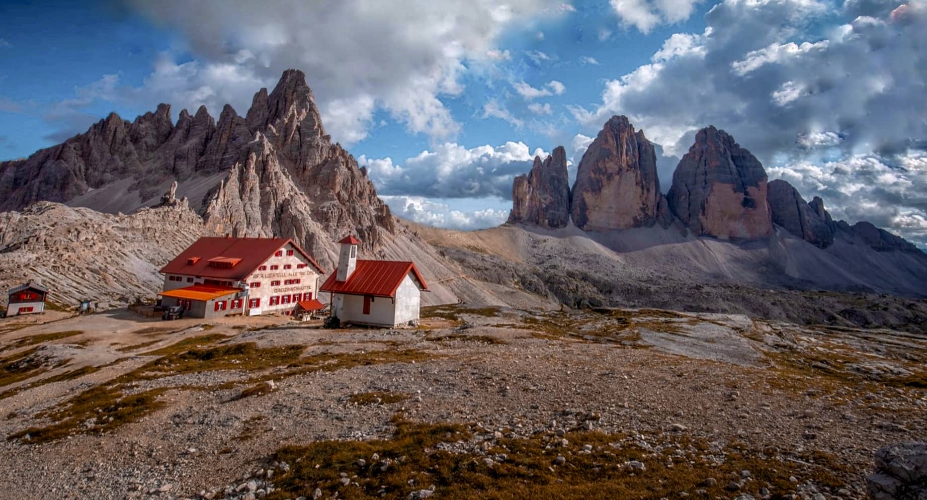
The Rifugio Locatelli can be seen in the distance; its red roof stands out among the rocks, indicating your next destination.

Rifugio Locatelli is a popular spot located beneath the Toblin Tower and the Sasso di Sesto.
It is an important crossroads for hiking in the Dolomites; hikers from Val Fiscalina, Rifugio Pian di Cengia, and Comici can also be found here.
Probably because the view from Rifugio Locatelli is spectacular: the Tre Cime di Lavaredo rise like three massive towers of rock stretching towards the sky.
Rifugio Locatelli is also an excellent place to stop for a break, either with a packed lunch or in the rifugio (if it’s open). During the summer, it is nearly impossible to find a place to eat; it is always best to make a reservation.
At this point, you have completed half of the Tre Cime di Lavaredo loop.

If you are tired, you can return along the same path you took out. If, on the other hand, you wish to continue with the tour, then take path 105 from Rifugio Locatelli towards Malga Langalm (also called Malga dei Pastori), a beautiful alpine hut set right beneath the Three Peaks.
The route begins with a steep descent followed by a steep ascent, but it then continues without any particular technical difficulties, passing through Col Forcellina and then Forcella di Mezzo before returning to Rifugio Auronzo.
How do you get to Tre Cime di Lavaredo?
Rifugio Auronzo, located near the Tre Cime, is the best way to begin your hike of the Tre Cime di Lavaredo loop. It is possible to reach Rifugio Auronzo by car, via a toll road, or by taking the bus from Auronzo – Misurina or Dobbiaco. It is also possible to hike up to Rifugio Auronzo; however, the trip is obviously longer in terms of both time and elevation difference.

Getting to Rifugio Auronzo by Car
To get to the Rifugio Auronzo by car, take the SP49 north from Misurina and turn left at the signs for Rifugio Rin Bianco and Auronzo. The toll gate is located just after Lago d’Antorno.
The 7-kilometer-long toll road is open from 6 a.m. to 8 p.m. and is only open from mid-May to the end of October (the exact dates may vary from year to year depending on weather conditions). For more information check the Tourist office Auronzo-Misurina website.
The toll for the final stretch of road to the Rifugio Auronzo is quite high: 30.00 euros for a car, 20.00 euros for a motorcycle, and 45.00 euros for a camper; there is an additional charge for those who spend the night in the rifugio and return to the valley the next day.
Taking public transportation to the Auronzo Mountain Hut
Traveling by car to Rifugio Auronzo is the most convenient option, but it is not always the fastest, especially during the summer months when the road is very busy and queues are common. During the summer months, the cheapest, fastest, and most environmentally friendly way to reach Rifugio Auronzo is by public transportation.
There are two shuttle buses that run directly from Dobbiaco (train station or bus station) and Misurina to the Rifugio Auronzo.
The shuttles typically run only during the summer months, from June to mid-October; check the official websites for exact dates and times.
If you don’t have a car, you can take a train from Brunico, Fortezza, or San Candido to Dobbiaco.
For more information check the official website.
Walking to the Tre Cime di Lavaredo
It is also possible to reach the Tre Cime on foot, beginning at the valley’s bottom; this is the best way to enjoy the beauty of the landscape and experience it without the stress of parking lots or buses packed with tourists.
There are numerous routes to the Tre Cime di Lavaredo, the most well-known of which is a three-hour hike from Antorno Lake to the Rifugio Auronzo. The elevation difference is 463 meters; or from San Candido/Valle Campo di Dentro to Rifugio Locatelli via the Rifugio Tre Scarperi. Duration: 6 hours, altitude difference: 1030 meters.
What time does Tre Cime open?
The toll road to Rifugio Auronzo is the only way to get to the closest point to the Three Peaks by car, and it is only open in the summer through October, from 6 a.m. to 8 p.m. (For more information, call + 39 0435 39109).
The season runs from May to November, but the exact dates vary depending on the weather. In the winter, however, it is closed to traffic and cannot be used with personal vehicles.
For updated information on opening times please contact the Tre Cime tollbooth at +39 0435 39109 or the Consorzio Turistico Tre Cime (Auronzo di Cadore) at +39 0435 99603.
Share and Follow
I hope this post was highly helpful in letting you experience the best of Tre Cime di Lavaredo. Let me know about your experience in the comments, and please share any tips you have for other travelers.
If you’re planning a trip to Italy, here’s a handy guide to help you plan your itinerary.
If you found this guide useful, please share it on social media.
To stay up to date, follow me on social media.
